Warning Signals Before Disaster
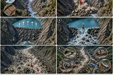
High in the mountain passes, a glacier suddenly tore loose. Millions of tonnes of ice and shattered rock tumbled into the river gorge below, forming an impromptu natural dam. When that fragile barrier ruptured under mounting hydrostatic pressure, a terrifying torrent of water, mud, ice, and boulders raced toward settlements downstream. It all unfolded in minutes. Broad stretches of land were obliterated, leaving more than six hundred confirmed dead and nearly three thousand missing – souls who may never be found.
The recent humanitarian catastrophe along the Nepal-Tibet border raises an urgent question: could advanced Himalayan early warning systems predict such calamities and give communities sufficient window to evacuate? The realistic answer is encouraging, yet nuanced. Modern technology can spot many impending hazards, though predicting every sudden mountain collapse remains beyond our reach.
Vigilance from Orbit
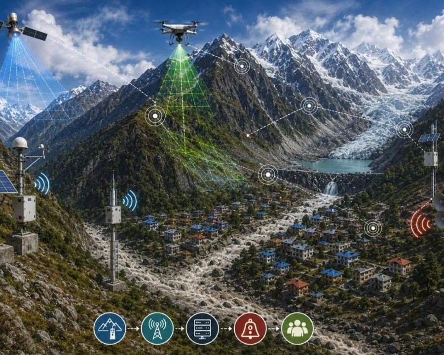
In rugged, inaccessible terrains like the Himalayas, orbital satellites serve as our frontline sentinels. By analysing multi-spectral satellite imagery, glaciologists can identify which glaciers are retreating rapidly, where new proglacial lakes are pooling, which existing glacial lakes are expanding dangerously, and whether steep rock faces are slowly creeping downhill. Comparing historical satellite passes side by side exposes minuscule surface displacements, enabling scientists to flag perilous zones long before disaster strikes.
Sensors on the Mountain Slopes
Alongside orbital surveillance, ground sensors can be deployed directly onto hazardous ridges and glacier tongues. Arrays of borehole inclinometers, acoustic crack sensors, and seismometers continually track slope displacement, widening crevasses, and subsurface micro-seisms. Catastrophic rockslides or glacial detachments often begin with subtle microscopic tremors. If sensors register these preliminary warnings, early alarms can be broadcast. Yet not every collapse produces detectable precursory signals, which remains a key engineering challenge.
Laser Eyes on Shifting Ridges
Light Detection and Ranging (Lidar) technology plays a transformative role. By firing rapid laser pulses from aircraft or drones, lidar constructs ultra-precise three-dimensional topographic models of mountain surfaces. Repeated seasonal sweeps reveal subtle changes in slope volume, emerging fissures, or ice subsidence. Terrestrial lidar scanners fixed opposite high-risk cliffs provide continuous volumetric monitoring. Paired with synthetic aperture radar, seismic arrays, and differential GPS stations, our ability to detect slope destabilization expands dramatically. Lidar cannot divine the future, but it makes invisible planetary strain visible.
Guarding High Glacial Lakes
Melting alpine glaciers frequently pool behind moraine dams composed of unconsolidated boulders, gravel, and permafrost. If these moraines give way, a massive volume of water surges downstream in what glaciologists classify as a Glacial Lake Outburst Flood (GLOF). Automated water-level gauges can be installed on these high-altitude lakes. Sudden surges or abrupt drops in water level immediately transmit telemetry via satellite. For particularly precarious lakes, controlled drainage channels or siphon networks can siphon off lake volume to safe levels, an approach already piloted on several perilous lakes in Nepal.
Rivers Sounding the Alarm
Equally vital is establishing automated hydrological monitoring cascades down alpine river channels. Suppose an upstream moraine fails in Tibet. Upstream streamflow sensors register an abnormal flood crest within seconds, relaying live telemetry to regional hydrological hubs. Centralized computing models calculate the downstream arrival moment of the surge for each village. Automated warning sirens can sound immediately, while geofenced emergency alerts flash across civilian mobile phones without waiting for manual human deliberation.
Ten Minutes That Save Lives
The core challenge in steep Himalayan canyons is sheer velocity. Flash floods and debris flows travel with furious momentum. After a trigger is detected, communities downstream might have only ten to twenty minutes to react. While that sounds agonizingly brief, pre-planned evacuation protocols, clear uphill escape routes, and designated safe havens can turn those ten minutes into the difference between life and death for thousands of residents. Installing technology alone is useless without community drills and disaster preparedness education.
Destruction Without Borders
Natural hazards in the Himalayas know no national frontiers. A disaster born high in Tibet can unleash havoc downstream across Nepal, which subsequently flows directly into river basins in India and Bangladesh. Managing this requires cross-border hydrological data sharing between China, Nepal, India, Bhutan, and Bangladesh. The moment upstream telemetry detects an outburst, downstream nations must receive instantaneous notification.
Preventing Preventable Deaths
Humanity cannot prevent the fundamental forces of nature. Glaciers will calve. Saturated slopes will collapse. Relentless monsoon cloudbursts will swell mountain rivers. Yet in the twenty-first century, we possess orbital satellites, lidar mapping, seismic networks, automated weather stations, hydrological models, and mobile alert systems. Merging these technologies into a unified regional network provides the Himalayas with resilient protection. We cannot abolish mountain hazards, but we can prevent natural disasters from turning into mass graves. That is the essential lesson of recent Himalayan tragedies.