Frequent Earthquakes in Bangladesh: Geological Risks and Preparedness
Recent Seismic Tremors: Isolated Jars or Warning Signals?
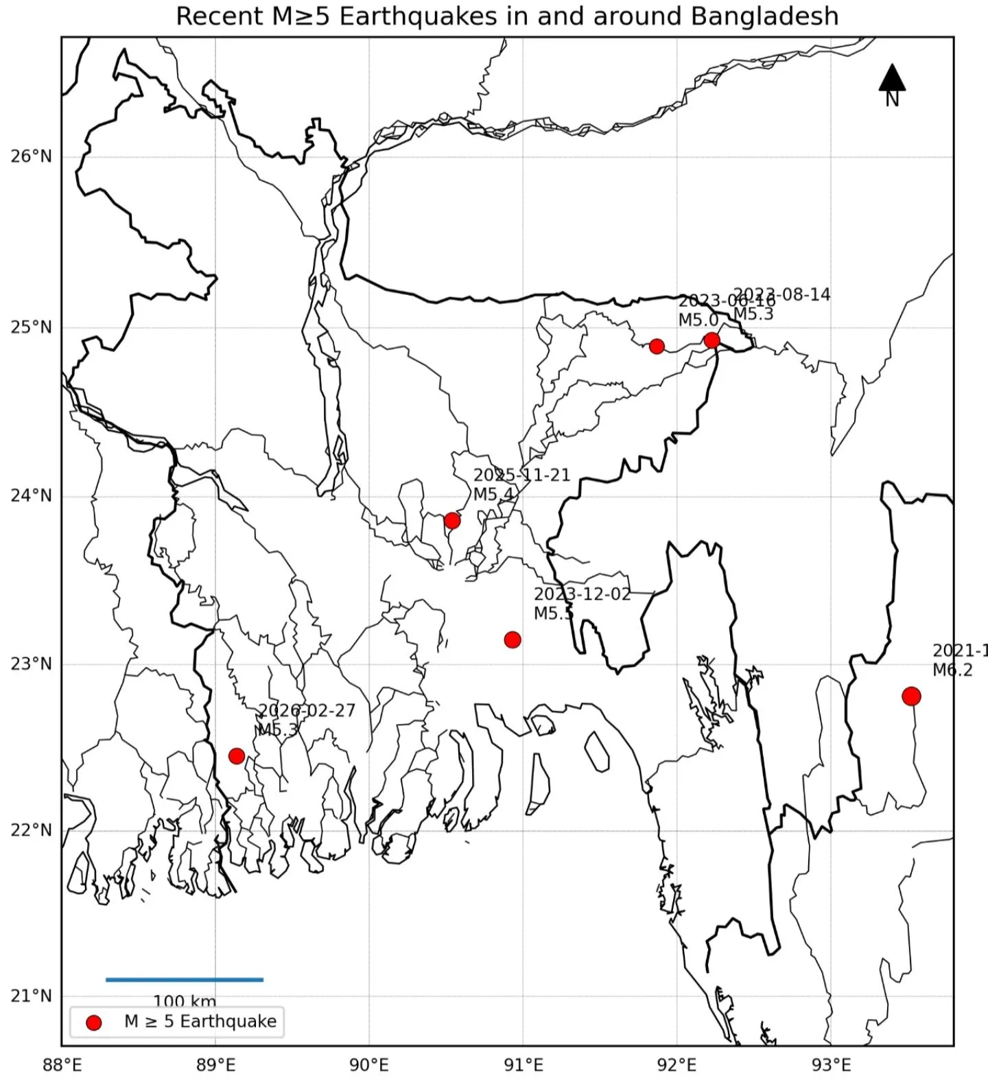
In recent years, Bangladesh and its surrounding borderlands have experienced multiple moderate tremors registering magnitudes between 5.0 and 6.2. Events recorded in northeastern India-Myanmar, Sylhet, Ramganj, Narsingdi-Dhaka, and Satkhira have caused heightened public concern. While structural damages remained limited, these tremors prompt an essential scientific question: are these minor events merely routine isolated shifts, or do they foreshadow a catastrophic mega-earthquake?
Tectonic Setting and Plate Boundary Dynamics
The Earth’s outer shell consists of dynamic tectonic plates locked in continuous motion. Bangladesh occupies a uniquely vulnerable geologic crossroads. To the north, the Indian Plate relentlessly collides with the Eurasian Plate at roughly 4 to 5 centimeters annually, uplifting the Himalayas. To the east, the Indian Plate subducts beneath the Burma microplate along the Indo-Burma subduction zone. Positioned directly between these two active tectonic regimes, the crust beneath Bangladesh steadily accumulates immense tectonic stress along locked fault interfaces.
Historical Precedents: The Legacy of Great Quakes
Geological and historical archives demonstrate that large-magnitude earthquakes are an integral reality of this region. The colossal Great Assam Earthquake of 1897 (magnitude 8.2+) caused widespread devastation across northeast India and Bengal, destroying masonry buildings in Dhaka and fundamentally altering topographic relief. In 1918, the Srimangal earthquake (magnitude 7.6) struck the Sylhet basin with devastating intensity. These historic disasters underscore that the region possesses the geomechanical capacity to unleash catastrophic seismic energy.
Landscape Reshaping and Hydrological Shifts
Major earthquakes in alluvial river deltas do more than demolish surface structures; they reshape rivers and geography. Historical accounts and sedimentological records reveal that the formidable 1762 Arakan earthquake altered coastal elevations and river discharge networks. Regional tectonic uplifts and co-seismic liquefaction, combined with seasonal monsoon floods, permanently altered the course of the Brahmaputra River—shifting its primary flow from the Old Brahmaputra channel toward the modern Jamuna channel.
The Threat of Locked Fault Lines
While moderate tremors release small fractions of localized strain, seismologists caution that they do not prevent major ruptures. If high-displacement fault zones—most notably the Dauki Fault along the southern margin of the Shillong Plateau or the massive locked megathrust of the Indo-Burma arc—remain locked for centuries, they accumulate strain deficits sufficient to produce earthquakes of magnitude 8.0 or greater.
Alluvial Soil and Site Amplification Hazards
A critical factor determining earthquake damage is the local soil profile. Dhaka and surrounding deltaic cities are constructed atop thick strata of soft alluvial sediment. When seismic shear waves traverse uncompacted silt and clay deposits, they undergo site amplification, magnifying ground shaking intensity significantly compared to hard bedrock. Combined with extreme population density, unplanned urbanization, vulnerable unreinforced masonry, and narrow emergency access routes, seismic risk is magnified exponentially.
Mitigation, Retrofitting, and Community Preparedness
Earthquakes cannot be prevented, but disaster vulnerability can be systematically managed. Nations like Japan and Chile face intense seismicity yet minimize casualties through strict building codes, base isolation technology, and nationwide drill routines. For Bangladesh, enforcing updated seismic building codes, identifying and structurally retrofitting hazardous infrastructure (hospitals, schools, bridges), and strengthening emergency response capabilities are essential steps toward building seismic resilience.